Weather Radar
Data Sources
Local Weather Radar displays weather information from established, publicly available meteorological data providers.
Radar Imagery
Radar maps on this site come from RainViewer, which aggregates radar data from national weather services around the world. In the United States, this data originates from the NEXRAD (Next-Generation Radar) network operated by the National Weather Service (NWS), a division of NOAA.
Radar imagery updates approximately every 10 minutes and shows precipitation intensity and cloud cover across each city's coverage area.
Weather Forecasts
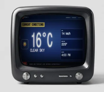
Current conditions, hourly forecasts, and 7-day forecasts are provided by Open-Meteo, an open-source weather API. Open-Meteo sources its data from multiple national meteorological agencies, including:
- NOAA / NWS (United States) — GFS, HRRR, and NAM models
- DWD (Germany) — ICON model
- Environment and Climate Change Canada — GEM model
- Météo-France — ARPEGE and AROME models
Update Frequency
| Data Type | Source | Update Interval |
|---|---|---|
| Radar imagery | RainViewer (NEXRAD) | ~10 minutes |
| Current conditions | Open-Meteo | ~30 minutes |
| Hourly forecast | Open-Meteo | ~1 hour |
| 7-day forecast | Open-Meteo | ~6 hours |
Accuracy
Weather data accuracy depends on the upstream models and radar networks. Radar imagery is observational data (what is actually happening), while forecasts are model predictions that become less precise further into the future. For official warnings and emergency information, always refer to your local National Weather Service office at weather.gov.
No Proprietary Data
This site does not generate its own weather models or radar data. All meteorological information comes from the sources listed above. We do not claim to produce, modify, or enhance the underlying data.
City Weather radar
- United States
-
- Abilene, Texas
- Akron, Ohio
- Alabama, Alabama
- Albany, Georgia
- Albany, New York
- Albuquerque, New Mexico
- Amarillo, Texas
- Anderson, Indiana
- Anderson, South Carolina
- Ann Arbor, Michigan
- Appleton, Wisconsin
- Arkansas, Arkansas
- Arlington, Texas
- Arlington, Virginia
- Asheville, North Carolina
- Atlanta, Georgia
- Auburn, Alabama
- Augusta, Georgia
- Augusta, Maine
- Austin, Texas
- Baltimore, Maryland
- Baton Rouge, Louisiana
- Battle Creek, Michigan
- Bay City, Michigan
- Bay City, Texas
- Baytown, Texas
- Beaumont, Texas
- Billings, Montana
- Biloxi, Mississippi
- Birmingham, Alabama
- Bismarck, North Dakota
- Bloomington, Illinois
- Bloomington, Indiana
- Bloomington, Minnesota
- Boca Raton, Florida
- Boise, Idaho
- Bradenton, Florida
- Branson, Missouri
- Brownsville, Texas
- Brunswick, Georgia
- Buffalo, New York
- California, California
- Canton, Ohio
- Cape Coral, Florida
- Champaign, Illinois
- Charleston, South Carolina
- Charlotte, North Carolina
- Chattanooga, Tennessee
- Chicago, Illinois
- Cincinnati, Ohio
- Cleveland, Ohio
- Colorado, Colorado
- Colorado Springs, Colorado
- Columbia, Missouri
- Columbus, Ohio
- Columbus, Georgia
- Cookeville, Tennessee
- Corpus Christi, Texas
- Cullman, Alabama
- Dallas, Texas
- Dayton, Ohio
- Daytona Beach, Florida
- Denver, Colorado
- Des Moines, Iowa
- Destin, Florida
- Detroit, Michigan
- Dothan, Alabama
- Duluth, Minnesota
- Durham, North Carolina
- El Paso, Texas
- Erie, Pennsylvania
- Evansville, Indiana
- Fayetteville, Arkansas
- Fayetteville, North Carolina
- Florence, Alabama
- Florida, Florida
- Fort Lauderdale, Florida
- Fort Myers, Florida
- Fort Smith, Arkansas
- Fort Wayne, Indiana
- Fort Worth, Texas
- Gainesville, Florida
- Gainesville, Texas
- Galveston, Texas
- Georgia, Georgia
- Greensboro, North Carolina
- Greenville, South Carolina
- Harlingen, Texas
- Harrisburg, Pennsylvania
- Hawaii, Hawaii
- Houma, Louisiana
- Houston, Texas
- Huntsville, Alabama
- Indianapolis, Indiana
- Iowa City, Iowa
- Jacksonville, Florida
- Joplin, Missouri
- Kalamazoo, Michigan
- Kansas City, Missouri
- Kenosha, Wisconsin
- Kentucky, Kentucky
- Kerrville, Texas
- Killeen, Texas
- Knoxville, Tennessee
- Kokomo, Indiana
- La Crosse, Wisconsin
- Lafayette, Indiana
- Lafayette, Louisiana
- Lake Charles, Louisiana
- Lakeland, Florida
- Lancaster, California
- Lancaster, Pennsylvania
- Lansing, Michigan
- Laredo, Texas
- Las Vegas, Nevada
- Lexington, Kentucky
- Lincoln, Nebraska
- Little Rock, Arkansas
- Los Angeles, California
- Louisville, Kentucky
- Lubbock, Texas
- Madison, Wisconsin
- Maine, Maine
- Maryland, Maryland
- McAllen, Texas
- McKinney, Texas
- Melbourne, Florida
- Memphis, Tennessee
- Michigan, Michigan
- Milwaukee, Wisconsin
- Minneapolis, Minnesota
- Minnesota, Minnesota
- Mississippi, Mississippi
- Missouri, Missouri
- Montgomery, Alabama
- Murfreesboro, Tennessee
- Muskegon, Michigan
- Myrtle Beach, South Carolina
- Naples, Florida
- Nashville, Tennessee
- Nebraska, Nebraska
- New Mexico, New Mexico
- New Orleans, Louisiana
- New York City, New York
- Norfolk, Virginia
- Norman, Oklahoma
- North Carolina, North Carolina
- North Dakota, North Dakota
- Oahu, Hawaii
- Ocala, Florida
- Oklahoma, Oklahoma
- Oklahoma City, Oklahoma
- Omaha, Nebraska
- Orlando, Florida
- Ormond Beach, Florida
- Oshkosh, Wisconsin
- Owensboro, Kentucky
- Paducah, Kentucky
- Palm Beach, Florida
- Panama City, Florida
- Pensacola, Florida
- Peoria, Illinois
- Philadelphia, Pennsylvania
- Phoenix, Arizona
- Pittsburgh, Pennsylvania
- Plano, Texas
- Port Charlotte, Florida
- Portland, Maine
- Portland, Oregon
- Punta Gorda, Florida
- Raleigh, North Carolina
- Richmond, Virginia
- Roanoke, Virginia
- Rochester, New York
- Rockford, Illinois
- Sacramento, California
- San Angelo, Texas
- San Antonio, Texas
- San Diego, California
- Sarasota, Florida
- Savannah, Georgia
- Seattle, Washington
- Sheboygan, Wisconsin
- Shreveport, Louisiana
- Slidell, Louisiana
- South Bend, Indiana
- South Florida, Florida
- Spartanburg, South Carolina
- Spokane, Washington
- Springfield, Illinois
- Springfield, Massachusetts
- Springfield, Missouri
- St. Augustine, Florida
- St. Louis, Missouri
- St. Paul, Minnesota
- St. Petersburg, Florida
- Stuart, Florida
- Syracuse, New York
- Tallahassee, Florida
- Tampa, Florida
- Tennessee, Tennessee
- Terre Haute, Indiana
- Texarkana, Texas
- Topeka, Kansas
- Tucson, Arizona
- Tulsa, Oklahoma
- Tuscaloosa, Alabama
- Tyler, Texas
- Utah, Utah
- Valdosta, Georgia
- Vero Beach, Florida
- Virginia, Virginia
- Virginia Beach, Virginia
- Waco, Texas
- Washington, Washington
- Washington DC, District of Columbia
- Wausau, Wisconsin
- West Palm Beach, Florida
- Wichita, Kansas
- Wichita Falls, Texas
- Wilmington, North Carolina